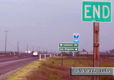
(End northbound State Route 33; San Joaquin County, California)
--Photo taken by Carlos Rogers in 2006 ✔
Viatype:S2-D
Map Location: 37.68322, -121.34498
The journey from Ventura (State Route 33's southern-terminus) ends here. For some reason or another, the State Route 33 shield is missing beneath the `End` postage.
Next
photo>>>
<<<Previous
photo
Distance Chart for
California 33
California 33
| Coalinga, California | |||||||
| 132 | Los Banos, California | ||||||
| 247 | 108 | Tracy, California | |||||
| 291 | 416 | 524 | Ventura, California | ||||
Approximate distance in km
(1 km = 0.621 miles)
(1 km = 0.621 miles)