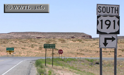
(Southbound US Federal Route 191; Navajo Nation [Apache
County Constituent], Arizona)
--Photo taken by Chris Elbert in 2005 ✔
Viatype:S2-U
Map Location: 36.93131, -109.57499![]()
Though the signage above doesn't indicate it, Federal Route 160 is the upcoming cross-street. If one completes a right-turn, he or she will be on the southbound US Federal Route 191/westbound US Federal Route 160 duplex.
Distance Chart for
Federal Route 191
Federal Route 191
| Douglas, Arizona | |||||||||
| 2613 | Loring, Montana | ||||||||
| 1122 | 1491 | Moab, Utah | |||||||
| 1404 | 1520 | 282 | Vernal, Utah | ||||||
| 2094 | 519 | 972 | 690 | Yellowstone Nat'l Park | |||||
Approximate distance in km
(1 km = 0.621 miles)
(1 km = 0.621 miles)