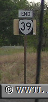
| (End Northbound State Route 39; Klamath Falls, Oregon) --Photo taken by Chris Elbert in 2005 ✔ Viatype:F4-D Klamath Falls is the hub of many Oregon state routes and one Federal Route. State Route 39 is a route that touches the southeastern outskirts of the major Oregon city.
|
Distance Chart for
Oregon 39
Oregon 39
| Klamath Falls, Oregon | |||||
| 35 | Merrill, Oregon | ||||
| 49 | 14 | Tulelake, California | |||
Approximate distance in km
(1 km = 0.621 miles)
(1 km = 0.621 miles)