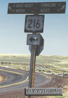
(Eastbound State Route 216; Wasco County, Oregon)
--Photo taken by Chris Elbert c. 2000s ✔
Viatype:S2-U
Map Location: 45.25771, -120.86239![]()
Since the design of Oregon state-highway shields are similar in appearance to their federal-route
counterparts, you sometimes get errors like this. The Oregon Department of
Transportation spotted this error a while back, and has since corrected it.
Distance Chart for
Oregon 216
Oregon 216
| Grass Valley, Oregon | |||||
| 47 | Pine Grove, Oregon | ||||
| 33 | 80 | Tygh Valley, Oregon | |||
Approximate distance in km
(1 km = 0.621 miles)
(1 km = 0.621 miles)