(Southbound Stoneridge Mall Road; Pleasanton, California)
--Photo taken by Carlos Rogers c. 2000s ✔
Viatype:F4-D
Map Location: 37.69485, -121.93184![]()
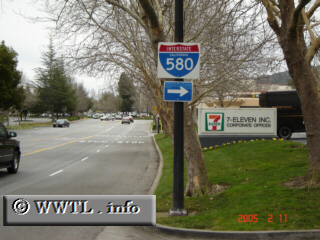
Here's an interesting piece found at Pleasanton's Stoneridge Mall--an Interstate guidance shield in non-cutout form. This is similar to what you'd see in Wisconsin, but instead of using that state's "black-box" format, it instead uses a white-box.
Distance Chart for
Interstate 580
Interstate 580
| Oakland, California | |||||
| 35 | San Rafael, California | ||||
| 87 | 122 | Tracy, California | |||
Approximate distance in km
(1 km = 0.621 miles)
(1 km = 0.621 miles)