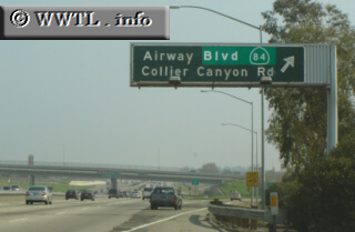
(Eastbound Interstate 580; Livermore, California)
--Photo taken by Carlos Rogers c. 2000s ✔
Viatype:F8-D
Map Location: 37.7009, -121.8228![]()
Junction CA-84 . Note the green-out including the Highway 84's shield--in mid 2004, this state-route's eastern-terminus ran along First Street in Livermore. Since then, it has been moved onto Airway Boulevard
Next
photo>>>
<<<Previous
photo
Distance Chart for
Interstate 580
Interstate 580
| Oakland, California | |||||
| 35 | San Rafael, California | ||||
| 87 | 122 | Tracy, California | |||
Approximate distance in km
(1 km = 0.621 miles)
(1 km = 0.621 miles)