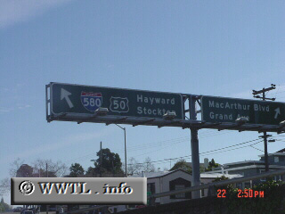
(Eastbound MacArthur Freeway; Oakland, California)
--Photo taken by Carlos Rogers c. 2000s ✔
Viatype:F6-D
Map Location: 37.81857, -122.25351![]()
A relic from the past: an Interstate 580/Federal Route 50 overhead. This sign shouldn't exist (as Federal Route 50 was truncated to Sacramento years ago).
Next
photo>>>
<<<Previous
photo
Distance Chart for
Interstate 580
Interstate 580
| Oakland, California | |||||
| 35 | San Rafael, California | ||||
| 87 | 122 | Tracy, California | |||
Approximate distance in km
(1 km = 0.621 miles)
(1 km = 0.621 miles)