(End Southbound State Route 75; San Diego, California)
--Photo taken by Eric Lozaga c. 2000s ✔
Map Location: 32.58376, -117.0908![]()
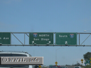
Notice how the Interstate 5 North overhead displays San Diego, and Interstate 5 South has no control point. Tijuana lies five miles south of this interchange. Interestingly in this Mexican municipality, Nat'l Routes 1D and 2D show San Diego as a northern control point.
Distance Chart for
California 75
California 75
| Coronado, California | |||||
| 14 | Imperial Beach, California | ||||
| 10 | 24 | San Diego, California | |||
Approximate distance in km
(1 km = 0.621 miles)
(1 km = 0.621 miles)