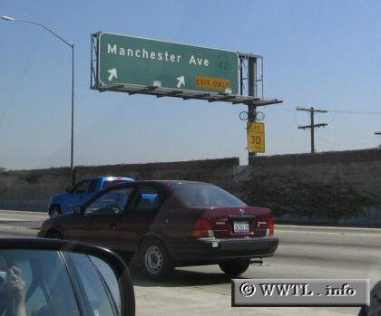
(Junction former State Route 42 @ Interstate 110 north; Los
Angeles, California)
--Photo taken by Melinda Nichols c. 2000s ✔
Viatype:F4-D
Map Location: 33.95691, -118.28045![]()
Here's a perspective from Interstate 110. Note how CalTrans has removed the State Route 42 shield from the overhead-assembly, but interestingly a footprint of the former-shield is conspicuously visible.
Distance Chart for
Former California 42
Former California 42
| Downey, California | |||||
| 21 | Inglewood, California | ||||
| 8 | 29 | Norwalk, California | |||
Approximate distance in km
(1 km = 0.621 miles)
(1 km = 0.621 miles)