(Westbound 16th Street.; Upland, California)
--Photo taken by Carlos Rogers c. 2000s ✔
Viatype:S4-D
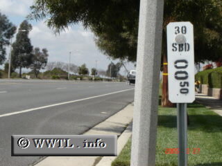
Shortly before State Route 30 West crossed into Claremont, a path was forged along
16th Street. Proof of prior existence was found half-a-mile
from Claremont city-limits. A post-mile marker (i.e., California's version
of mileage-markers) displayed the number "30" for highway-definition. The
uppermost field of Californian post-miles denote the route's legislative
definition (i.e., number).
Distance Chart for
Former California 30
Former California 30
| San Antonio Heights, California | |||
| 17 | San Bernardino, California | ||
Approximate distance in km
(1 km = 0.621 miles)
(1 km = 0.621 miles)