| | 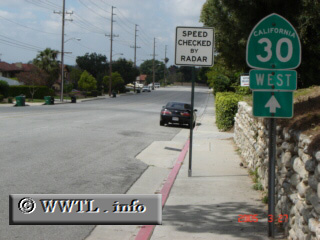
(Westbound Base Line Road; Claremont, California)
--Photo taken by Carlos Rogers c. 2000s ✔
Viatype:S2-U
Highway 30, once the main arterial for the northern stretches of eastern Los
Angeles and western San Bernardino Counties, fell into
obsolescence with the construction of a next-generation bypass, the State Route 210
freeway. As of 2005, California's state-logs no longer acknowledge the two-digit route. Signage for the highway is all but disappearing, and its
memory is honoured with these following photographs.
Next
photo>>>
| <
|