(Eastbound Imola Avenue; Napa, California)
--Photo taken by Carlos Rogers c. 2000s ✔
Viatype:S2-U
Map Location: 38.28168, -122.28562![]()
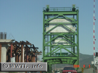
Now we're traveling east towards a steel-deck drawbridge. The bridge is being deprecated in favour of a concrete-span, being constructed to the left.
Distance Chart for
California 121
California 121
| Moskowite Center, California | |||||
| 24 | Napa, California | ||||
| 42 | 86 | Sears Point, California | |||
Approximate distance in km
(1 km = 0.621 miles)
(1 km = 0.621 miles)