| | 
(Junction State Route 100; Santa Cruz, California)
--Photo taken by Carlos Rogers c. 2000s ✔
Viatype:F4-D
Map Location: 36.99306, -122.01936 According to the
California Streets and Highway Code (CSHC)
, State Route 100 "...is from the junction of Routes 1 and 17 to Route 1
west of the San Lorenzo River via the beach area in Santa Cruz".
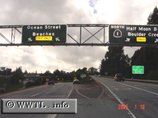
Pictured above is the western beginning of State Route 100 along northbound State Route 1. Highway 100 uses the left-fork, ushering motorists into Santa Cruz and the vicinity of its beach boardwalk. According to the
California Streets and Highway Code (CSHC)
, State Route 100 "...is from the junction of Routes 1 and 17 to Route 1
west of the San Lorenzo River via the beach area in Santa Cruz".
Pictured above is the western beginning of State Route 100 along northbound State Route 1. Highway 100 uses the left-fork, ushering motorists into Santa Cruz and the vicinity of its beach boardwalk.
Next
photo>>>
|
|