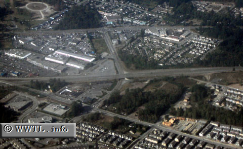
(Junction Route 99; Vancouver, British Columbia)
--Photo taken by Carlos Rogers in 2005 ✔
Viatype:F4-D
Map Location: 49.06131, -122.80513![]()
English | français
...Looking west along 32 Avenue. Route 99 is the highway running in the middle of the photograph, from left to right. Next
photo>>>
<<<Previous
photo
Distance Chart for
British Columbia 99
British Columbia 99
| Lillooet | |||||||||
| 100 | Pemberton | ||||||||
| 189 | 91 | Squamish | |||||||
| 252 | 153 | 64 | Vancouver | ||||||
| 131 | 33 | 59 | 121 | Whistler | |||||
Approximate distance in km
(1 km = 0.621 miles)
(1 km = 0.621 miles)