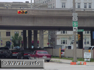
(Southbound Broadway; Milwaukee, Wisconsin)
--Photo taken by Carlos Rogers c. 2000s ✔
Map Location: 43.03725, -87.90686![]()
Highway 32 runs through the downtown of Milwaukee, connecting Illinois to Michigan. Notice the red spots to the left and right of the highway-number? These are actually arrow-shaped figures, posted in memorial of the the 32nd "Red Arrow" Division*--a proud group of WI/MI National Guardsmen whom served during World War I.
*Thanks to Eric Stuart for providing background information on the red-arrows and the 32nd Division.
Distance Chart for
Wisconsin 32
Wisconsin 32
| Crandon | |||||||||
| 61 | Eagle River | ||||||||
| 223 | 168 | Green Bay | |||||||
| 258 | 255 | 229 | Kenosha | ||||||
| 256 | 255 | 194 | 223 | Milwaukee | |||||
Approximate distance in km
(1 km = 0.621 miles)
(1 km = 0.621 miles)