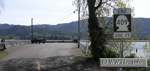
(End Southbound State Route 409; Puget Island, Washington State)
--Photo taken by Chris Elbert c. 2000s ✔
Viatype:S2-U
Map Location: 46.15435, -123.37747
Washington State Route 409 connects Puget Island, an island in southwestern state, with Cathlamet. At her southern terminus, pictured above, ferry access to Westport, OR is offered.
Distance Chart for
State Route 409
State Route 409
| Cathlamet | |||||
| 4.5 | Puget Island | ||||
| 15.5 | 11 | Westport, OR | |||
Approximate distance in km
(1 km = 0.621 miles)
(1 km = 0.621 miles)