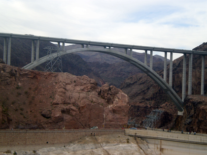
(US Federal Route 93; Arizona-Nevada stateline)
--Photo taken by Sharon Marceline
Viatype:F4-D
Map Location:
36.0125, -114.74206![]()
At the Hoover Dam crossing, Federal Route 93 rises majestically in the background.
<<<Previous photo
Distance Chart for
Federal Route 93
Federal Route 93
| Eureka, Montana | |||||||||
| 1971 | Las Vegas | ||||||||
| 481 | 1451 | Missoula, Montana | |||||||
| 1103 | 868 | 622 | Twin Falls, Idaho | ||||||
| 2345 | 374 | 1864 | 1242 | Wickenburg, Arizona | |||||
Approximate distance in km
(1 km = 0.621 miles)
(1 km = 0.621 miles)