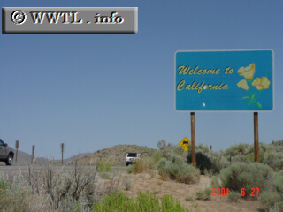
(Northbound Federal Route 395; California-Nevada border)
--Photo taken by Carlos Rogers in 2005 ✔
Viatype:F8-D
Map Location: 39.6739, -120.00112![]()
This picture was taken from Washoe County, NV looking into Sierra County, California.
Distance Chart for
Federal Route 395
Federal Route 395
| Burns, Oregon | |||||||||
| 1294 | Hesperia, California | ||||||||
| 806 | 2100 | Laurier, Washington State | |||||||
| 692 | 820 | 1033 | Reno, Nevada | ||||||
| 431 | 1725 | 375 | 1033 | Yakima, Washington State | |||||
Approximate distance in km
(1 km = 0.621 miles)
(1 km = 0.621 miles)