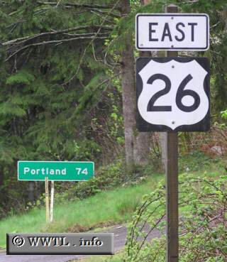
(Eastbound Federal Route 26; Clatsop County, Oregon)
--Photo taken by Chris Elbert c. 2000s ✔
Viatype:S2-U
This is the first `26 East` shield along the route's path to Ogallala, Nebraska.
Distance Chart for
Federal Route 26
Federal Route 26
| Boise, Idaho | |||||||||
| 860 | Cannon Beach, Oregon | ||||||||
| 628 | 1178 | Grand Teton Nat'l Park | |||||||
| 1657 | 2387 | 909 | Ogallala, Nebraska | ||||||
| 728 | 122 | 1356 | 2265 | Portland, Oregon | |||||
Approximate distance in km
(1 km = 0.621 miles)
(1 km = 0.621 miles)