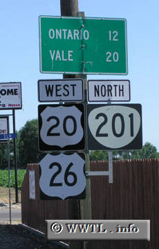
(Westbound Federal Route 20/Federal Route 26/OR-201; Malheur County, Oregon)
--Photo taken by Chris Elbert c. 2000s ✔
Viatype:S2-U
Map Location: 43.88615, -117.00622![]()
The route triplexes with Federal Route 26 and OR-201 between Nyssa and the outskirts of Ontario.
Next photo>>>
<<<Previous photo
Distance Chart for
Federal Route 20
Federal Route 20
| Boston | |||||||||
| 1631 | Chicago | ||||||||
| 1048 | 583 | Cleveland | |||||||
| 3895 | 2264 | 2847 | Newport, Oregon | ||||||
| 2467 | 836 | 1419 | 1428 | West Yellowstone, Montana | |||||
Approximate distance in km
(1 km = 0.621 miles)
(1 km = 0.621 miles)