(Southbound Ventura Freeway; Ventura County, California)
--Photo taken by Carlos Rogers c. 2000s ✔
Viatype:F4-D
Map Location: 34.35156, -119.42619![]()
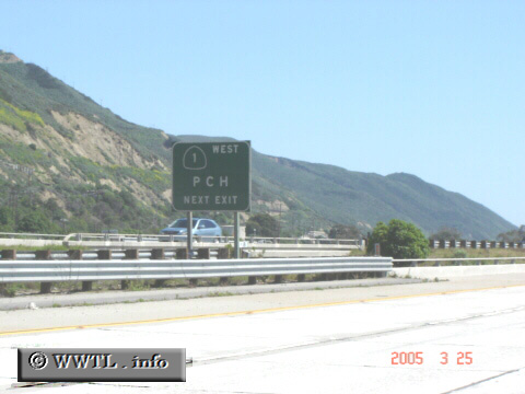
Just east of Mussel Shoals, this unique sign shows up; this seems to be the only sign in California which indicates CA-1 as an "east-west" route--and even more incredible, it's not an anomaly! Interestingly, CA-1 gets legislatively defined as a short (~four mile) strip of frontage-road between the Santa Barbara-Ventura county line & the city of Ventura.
Next photo>>>
<<<Previous
photo
Distance Chart for
Federal Route 101
Federal Route 101
| Astoria, Oregon | |||||||||
| 721 | Eureka, California | ||||||||
| 1835 | 1114 | Los Angeles, California | |||||||
| 580 | 1301 | 2415 | Olympia, Washington | ||||||
| 1159 | 438 | 676 | 1739 | San Francisco, California | |||||
Approximate distance in km
(1 km = 0.621 miles)
(1 km = 0.621 miles)