(Northbound E. San Ysidro Boulevard; San Ysidro community, San
Diego, California)
--Photo taken by Carlos Rogers c. 2000s ✔
Viatype:F8-D
Map Location: 32.54493, -117.03007![]()
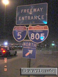
Once motorists cross from Tijuana, BC, México into San Diego, CA, USA, a
duplex of Interstates 5 and 805 is formed. About half-a-mile north of this
border crossing, these two routes split from one another.
Next
photo>>>
<<<Previous
photo
Distance Chart for
USA Interstate 5
USA Interstate 5
| Los Angeles | |||||||||
| 1550 | Portland, Oregon | ||||||||
| 194 | 1742 | San Diego, California | |||||||
| 618 | 932 | 810 | Sacramento, California | ||||||
| 1826 | 281 | 2020 | 1210 | Seattle | |||||
Approximate distance in km
(1 km = 0.621 miles)
(1 km = 0.621 miles)