France   

 
(Eastbound D14; Hautes-Alpes)
--Photo taken by Carlos Rogers in 2005
Viatype:S2-U
Map Location: 44.65415, 6.08526

English | français

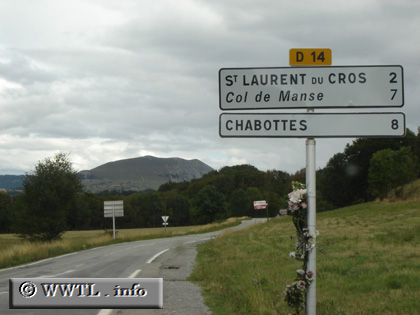
D14 connects the Napoleon Highway with  Chabottes.  Many European atlases mislabel the double digit-route as "D114".

Share with:
XFacebookWhatsAppReddit


Distance Chart for
D14 d'Haute-Savoie
La Bâtie-Neuve, Hautes-Alpes
6.6La Rochette, Hautes-Alpes
136.3Saint-Laurent-de-Cros, Hautes-Alpes
Approximate distance in km
(1 km = 0.621 miles)