| | 
(Eastbound Foothill Boulevard; Upland, California)
--Photo taken by Carlos Rogers c. 2000s ✔
Viatype:S4-D
Map Location: 34.10692, -117.6515
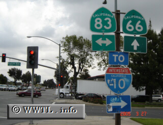
State Route 66, a remnant of Federal Route 66 in Los Angeles and San Bernardino
Counties, connects La Verne with San Bernardino. Most shields along the
route do not usually come in the California-shield flavour, but instead with
Historical Federal Route 66 signage
(outfitted with a US-shield and an outlying
brown box). However, at the junction of Euclid Avenue (pictured above), a
California-shield guides eastbound State Route 66 motorists.
| |