| | 
(Northbound Golden State Avenue; Bakersfield, California)
--Photo taken by Carlos Rogers c. 2000s ✔
Viatype:S4-D
Map Location: 35.35382, -119.00275
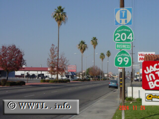
Before Interstate 5 came into existence,
the main corridor between Sacramento and Los Angeles was (former) Federal Route 99.
Throughout the San Joaquin Valley, Federal Route 99 was synonymous with the moniker
"Golden State Highway". Nowadays, Federal Route 99 no longer exists and
Interstate 5 has become the valley's main thoroughfare. Interestingly, the
Golden State Highway remains commemorated in Bakersfield, but not under the name
"State Route 99" (as one might think)--it goes by "State Route 204", and
although a freeway now parallels to its west, it interestingly still receives
state funds.
Next
photo>>>
| |