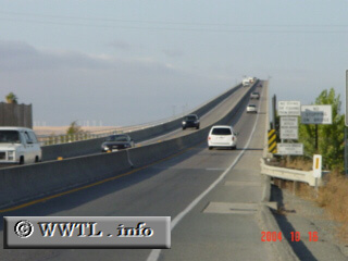
(Northbound Antioch Bridge; Contra Costa
County, California)
--Photo taken by Carlos Rogers c. 2000s ✔
Viatype:F4-D
Map Location: 38.01688, -121.75148![]()
Many bridges throughout the California Delta are drawbridges; however, the Antioch Bridge is not. This structure features a divided two lane high-rise, allowing motorboats to seamlessly pass under.
Next
photo>>>
<<<Previous
photo
Distance Chart for
California 160
California 160
| Antioch, California | |||||
| 28 | Rio Vista, California | ||||
| 74 | 102 | Sacramento, California | |||
Approximate distance in km
(1 km = 0.621 miles)
(1 km = 0.621 miles)